(+971) 4 3523678 / (+971) 55-1881446
(+971) 4 3523678 / (+971) 55-1881446
Sat-Thu: 08 am-06 pm
P560 adopts highstrength carbon fiber material. Novel body design, small size, light weight, smooth flight, flexible mobility, low air resistance and flight noise is the main characteristics. Meanwhile, P560 is more suitable for work on nighttime, harsh and personnelintensive environment.
P310 adopts hybrid configuration design of fixed wing and quadrotor, solving the difficulty of VTOL by this simple and reliable way. P310 has many characteristics, like long endurance, high speed, long flight range and large payload.
AP 5600 Micro Oblique Camera
Micro Oblique Camera AP5600 integrates one vertical and four oblique camera, which can be used for electric multi-rotor UAV to operate small area oblique photogrammetry mission with high Micro Oblique Camera Technical Instruction AP5600 image resolution. With professional software processing, the image captured by this camera can be constructed to high resolution and precision 3D model automatically..
The i80 represents the pinnacle of productivity on today’s jobsite. Leading technology with superior capabilities, the i80 has tracked all five constellations, ten frequencies, and uses every connectivity method available. The i80 is the smallest receiver on the market incorporating dual hot swappable batteries, allowing continuous uninterrupted work. All these features integrated into a small ergonomic package allows for the most productive day of surveying possible.
X91+ GNSS
The CHC X91+ GNSS is a compact GNSS receiver designed for high accuracy and productivity even in harsh environments. Powered by 220 channels GNSS core engine, the X91+ GNSS provides a costeffective solution to any surveying project. Easytouse, efficient and intuitive work flow, designed for advanced network RTK survey, compact and rugged, the X91+ is the perfect choice for demanding survey applications.
Key Features
HCE 300
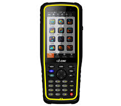
HCE300 is a professional GNSS data controller with alphanumerical keypad which will benefit more surveyors with great ease during the filed work. Meanwhile with 4.3” sunlight readable screen and faster processor, the HCE300 ensures you have higher efficiency and improved productivity.
As data controller, HCE300 is powered with rugged IP67 rating and 1.2 meter dropsurvival for the most demanding environment, in addition, the Liion battery with 6300 mAh battery capacity can keep you working for long time work without worries about the power supply.
LT 30
LT30 is a costeffective professional GPS/GIS handheld receiver with SBAS enabled highsensitivity GPS.
Designed for efficient field work in the most demanding conditions, LT30 features sharp VGA sunlight readable screen and up to 10 hours battery life.
LT 300
The CHC LT300 is a tablet computer designed for various outdoor data collection solutions with more convenience and efficiency in different application areas, like electric inspection, law enforcement and asset management.
The bigger screen and greater computing power make it play a greater role in the field working. Adopting GPS+BeiDou positioning module and Android 4.2 operation system, LT300 can run application software with more flexibility.
LT 500
The LT500 series is a rugged, versatile handheld GNSS receiver, covering three accuracy ranges from meter, submeter, to centimeter and is the most costeffective positioning solution for survey, construction and GIS professionals.
N 71 GNSS
Designed for seamless integration, the CHC N71 is a powerful multiapplication GNSS sensor which delivers stateoftheart positioning features in a rugged enclosure.
The CHC N71 GNSS sensor provides a costeffective answer to demanding applications such as geodetic reference station, academic research, precision agriculture RTK network, deformation monitoring, centimeter accuracy RTK sensor for marine survey, dredging or any GPS/GNSS machine guidance when high performances and reliability are required.
Key Features
N 72 GNSS
The CHC N72 GNSS sensor provides advanced multiindustry solutions to various demanding applications such as mining monitoring, geologic hazard monitoring, water conservancy monitoring, machine control, vehicle dispatching, etc. Easytouse, compact and rugged, designed for advanced monitoring performances, the N72 GNSS sensor makes field work more comfort for the surveyors.
P 700E Aircraft
The CHC P700E UAV is an independently developed fixed-wing unmanned aircraft that introduced by CHC. Featured by military-grade design, twin electric engines, large payload capacity, remarkable endurance and up to 25 square kilometers working range for single trip, P700E stands out among others of its kind in the market.
X20i GNSS
The CHC X20i GNSS receiver is powered by a high precision GNSS engine with the industry’s most trusted tracking technology.
X900+ GNSS
The X900+ GNSS receiver from CHC leverages the latest GNSS technology by integrating 120 channels with the ability to track GPS, GLONASS, Galileo and Beidou and field software dedicated to topographic and construction surveying. The X900 series is one of the most costeffective GNSS receiver selected by large number of surveyors for its outstanding performances and reliability..
X900S-OPUS
The CHC X900SOPUS dualfrequency GNSS receiver is designed to deliver every surveyor with high precision, robust performances and reliable technology at an affordable price. The X900SOPUS GNSS system matches a wide range of applications requiring postprocessing static or kinematic survey
CHC P3E
P3E GNSS sensor provides a cost-effective answer to demanding applications where high performances and reliabilities are required, including: geodetic reference stations, academic centimeter accuracy GNSS sensors for marine surveying, dredging, and GPS/GNSS machine guidance.
CHC Antenna
CHC GNSS antenna series provides a cost-effective solution to demanding positioning applications such as geodetic reference station, marine survey, dredging or GIS and mapping when high performances and reliability are required.
APACHE 5 USV
CHC today released the availability of the new generation USV - APACHE 5, which is the high-end USV designed for various applications and industries, such as geomorphological surveying and mapping, channel surveying, nuclear radiation measurement, underwater geological exploration and etc..